Introduction: When Archaeology Reopens an Old Historical Question
For most people, Elephanta Island near Mumbai is simply a tourist destination famous for its rock-cut Shiva sculptures. In school textbooks and travel brochures, it appears as a UNESCO World Heritage site, celebrated for the grand Maheshmurti, Nataraja, Ardhanarishvara, Gangadhara and other sculptural panels of Shaivism. UNESCO describes Elephanta as a “City of Caves” where Indian art found one of its finest expressions, especially in the great reliefs of the main cave.
But recent excavations at Morabandar on Gharapuri, better known as Elephanta Island, have forced historians to look beyond sculpture and religion. The Archaeological Survey of India has reported the discovery of two rare copper-plate inscriptions, along with evidence of water management, imported ceramics, Roman amphora fragments, West Asian torpedo jars, coins, iron objects, stone anchors and possible warehouse-like structures. These discoveries suggest that ancient Gharapuri was not only a sacred Shaivite centre but also a political, administrative and maritime hub linked to the wider Arabian Sea and Indian Ocean networks.
This is important because the new evidence touches an older historical debate: was the “Puri” mentioned in the famous Aihole inscription of Pulakeshin II actually Gharapuri? For decades, historians had debated whether Pulakeshin’s naval campaign against “Puri” referred to Rajapuri near Janjira or to Gharapuri near Mumbai. The new discoveries do not close the debate absolutely, because full epigraphic publication is still awaited, but they certainly strengthen the argument that Gharapuri may have been the ancient “Puri” described in the Chalukya record.
Background: Elephanta Before the New Excavations
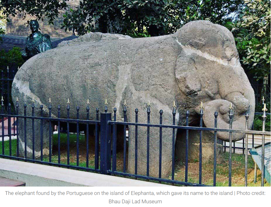
Elephanta, or Gharapuri, lies in Mumbai Harbour, roughly north-east of the Gateway of India. The ASI notes that the island is around 11 km from Apollo Bunder and about 7 km from the mainland shore. The name “Elephanta” came from the colossal stone elephant found on the island, later shifted to Jijamata Udyan in Mumbai. In older historical memory, however, the island was known as Gharapuri, often interpreted as “the city of caves.”
The caves are generally dated to around the 6th–7th centuries CE. The ASI identifies seven cave excavations in the Elephanta group, with Cave 1 being the most impressive example of mature Brahmanical rock-cut architecture. The central shrine, pillared hall and massive sculptural panels show a highly developed Shaivite religious programme.
Earlier, the island’s importance was usually discussed in terms of art history. The focus was on questions such as: Who patronised the caves? Were they created under the Kalachuris, the Konkan Mauryas, the Chalukyas, or another regional power? What is the meaning of the Maheshmurti? How does Elephanta compare with Ellora, especially Dumar Lena? These remain important questions. But the new excavation changes the frame: Elephanta must now be studied not merely as a religious monument, but as a living settlement with water systems, trade links, political documents and strategic maritime value.
The Aihole Inscription and the Question of “Puri”
The Aihole inscription of Pulakeshin II, composed by the court poet Ravikirti in 634–35 CE, is one of the most important inscriptions of early medieval India. It praises Pulakeshin II’s victories and presents him as a powerful ruler of the Deccan. Among its important references is the conquest of “Puri”, described as the glory or wealth of the western sea. The inscription refers to Pulakeshin’s attack on Puri with hundreds of ships, comparing them poetically to groups of intoxicated elephants.
This is remarkable because it indicates a naval campaign. Early medieval Indian warfare is often imagined in terms of land armies, cavalry, elephants and forts. But the Aihole reference points to a coastal target that required ships, and therefore to the strategic importance of the western coast.
The identity of this “Puri” has long been debated. Some scholars associated it with Rajapuri near Janjira in the Konkan. Others, including V. V. Mirashi, Dr Bhau Daji Lad and Harihar Thosar, connected it with Gharapuri/Elephanta. The ASI’s own description of Elephanta also notes that the ancient place has been identified with Puri mentioned in the Aihole inscription of Pulakeshin II.
The recent Morabandar discoveries now give this debate fresh archaeological weight. If Gharapuri had copper-plate records, imported ceramics, water infrastructure, coins and evidence of maritime activity, then it was not a minor island settlement. It was exactly the kind of coastal centre that could attract the attention of a major ruler like Pulakeshin II.
The New Discoveries at Morabandar
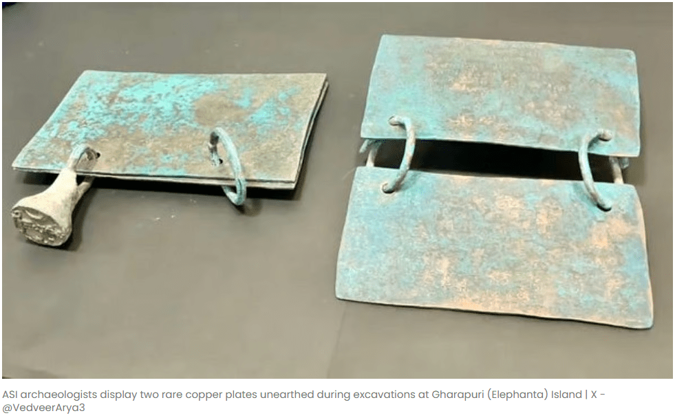
The excavation at Morabandar was conducted by the Archaeological Survey of India with associated academic participation. The most discussed finds are two copper-plate inscriptions discovered inside a large storage jar. According to the ASI statement reported by PTI, the inscriptions belong to the Traikutaka dynasty and the Chalukyas of Navasarika and were recovered during the 2025–26 field season.
The first copper plate is associated with Maharaja Indrasena of the Traikutaka dynasty. This is extremely important because Indrasena, or an early Traikutaka ruler connected with that name, was previously known mainly through later references and coins. The plate may therefore provide one of the earliest direct epigraphic records of the dynasty’s formative phase.
The details reported so far are historically rich. The Traikutaka copper plate reportedly mentions “Vijayi Aniruddhapura” and records a grant connected with the worship of Shankaranarayana. It refers to land near a tank and gives boundary markers such as trees, barren land, rocks, elevation and, significantly, the sea towards the north-west. Such boundary descriptions matter because they allow historians to reconstruct the local geography of the grant. The mention of the sea becomes especially important for connecting the document with an island landscape like Gharapuri.
The second copper plate has been provisionally attributed to Jayashraya Mangalarasa of the Chalukyas of Navasarika. This branch of the Chalukyas ruled parts of southern Gujarat, northern Konkan and the Nashik region during the 7th–8th centuries CE. However, the reading of this plate is still incomplete because conservation and chemical cleaning are ongoing. Therefore, historians must treat this inscription as highly promising but not yet fully settled evidence.
Water Management: A Settlement, Not Just a Shrine
One of the most significant discoveries is a large stepped water reservoir. The excavated structure is roughly 14.7 metres long, between 6.7 and 10.8 metres wide, and around 5 metres deep, with 20 steps exposed so far. It is not a simple rock-cut cistern. It was built with stone blocks, some of which are not native to the island, suggesting that material was transported from the mainland.
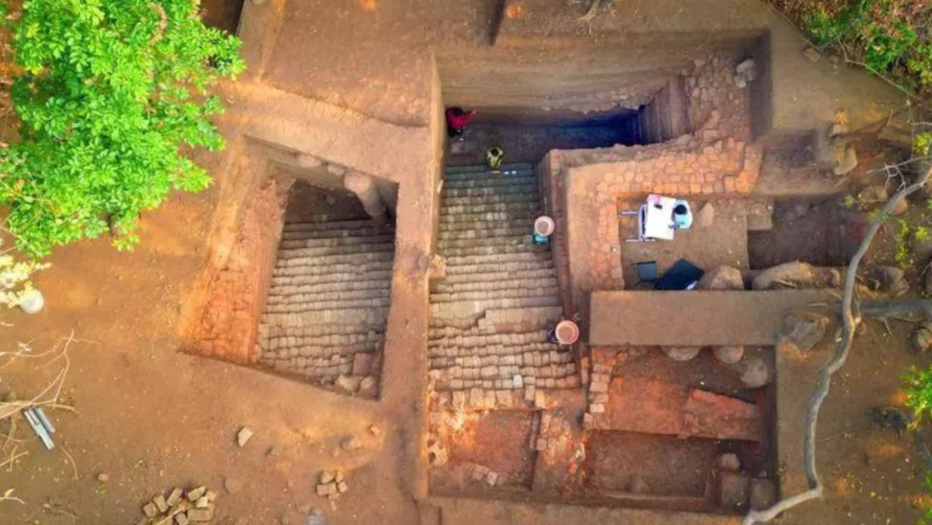
This is a crucial point. An island surrounded by seawater needs freshwater management. Gharapuri receives monsoon rainfall, but the rocky terrain does not retain water easily. A carefully built reservoir therefore indicates planning, labour mobilisation and long-term occupation. This cannot be explained merely as a facility for occasional pilgrims. It points to a settled and strategically maintained site.
From a historian’s perspective, water systems are evidence of social organisation. They show that people were not only worshipping on the island but living, storing, maintaining, supplying and possibly supporting maritime movement. If ships used the island as an anchoring point, freshwater would have been essential. Thus, the reservoir connects religious history with environmental archaeology and maritime history.
Evidence of Maritime Trade
The finds from Morabandar include Roman amphora fragments, West Asian torpedo jars, imported ceramics, glass, stone anchors, iron ingots, coins and possible warehouse-like structures. The ASI has interpreted these as evidence of substantial maritime activity and long-distance trade.
This shifts Elephanta from the category of “isolated sacred island” to “node in an exchange network.” The imported ceramics are particularly significant. Torpedo jars are associated with West Asian and Persian Gulf connections, while amphora fragments point to Mediterranean or Indo-Mediterranean trade circuits. The presence of such objects does not automatically mean that foreign merchants permanently lived on the island, but it certainly indicates that goods, containers, ships or exchange networks touched this place.
India Today’s report also notes that Gharapuri may have functioned as an anchoring or trans-shipment point, where goods could be transferred to smaller vessels for movement toward Kalyan, Thane and the mainland through the Ulhas Creek system.
This makes historical sense. Ancient and early medieval western India was deeply connected through coastal routes. Sopara, Kalyan, Chaul, Bharuch and other ports formed a chain of exchange. Gharapuri’s position in Mumbai Harbour made it suitable as a protected maritime station. It may not have been a large open market like some major ports, but it could have served as a controlled anchorage, storage point, religious centre and administrative node.
Coins and Political Control
The excavation has also produced coins, including copper coins linked to Kalachuri ruler Krishnaraja. Some coins reportedly show a bull and a temple-like symbol, which fits the wider religious-political culture of the period.
Coins are important because they help historians understand circulation, sovereignty and economic activity. A coin is not merely money; it is also a political sign. It carries symbols, names and claims of authority. If Kalachuri coins are found at Gharapuri, and copper plates of Traikutakas and Navasarika Chalukyas are also present, then the island appears as a space through which multiple political powers passed or competed.
This matches the ASI’s broader historical note that different dynasties held sway over the island, including the Konkan Mauryas, Traikutakas, Badami Chalukyas, Silaharas, Rashtrakutas, Kalyani Chalukyas, Yadavas, later Islamic powers, Portuguese, Marathas and British.
The political history of Gharapuri was therefore layered. It was not a monument frozen in time. It was a strategic possession, and its control mattered.
Historian’s Analysis: Why This Discovery Is Bigger Than It Looks
The importance of these discoveries lies in the convergence of three types of evidence: epigraphy, archaeology and geography.
First, epigraphy gives names, dynasties, grants and administrative language. The copper plates connect Gharapuri with Traikutaka and Chalukya power. They give historians textual anchors in a period where political control over the western coast was often fluid.
Second, archaeology gives material life. The reservoir, imported ceramics, coins, anchors and storage structures show occupation, movement, exchange and planning. This is the kind of evidence that prevents history from becoming only a story of kings and battles.
Third, geography explains why the site mattered. Gharapuri’s location in Mumbai Harbour made it defensible and useful. A ruler controlling Gharapuri could monitor maritime routes, access the Konkan coast, connect with Gujarat and link inland routes through Kalyan and Thane.
A political historian would see this as evidence of state formation in the western Deccan and Konkan. A maritime historian would see it as proof that the Arabian Sea was not a barrier but a highway. An economic historian would focus on imported ceramics, coins and storage structures as evidence of trade. An art historian would connect this wealth and political patronage with the creation of the Elephanta caves. A religious historian would note how Shaivism was embedded in political power, land grants and sacred geography.
This is precisely why the discovery is important as it does not merely add one new fact. It changes the questions we ask.
Gharapuri as Sacred Centre and Maritime Hub
The older view of Elephanta was dominated by its Shaivite sculptures. That view was not wrong, but it was incomplete. The new findings suggest that the sacred and the strategic were interlinked.
In early medieval India, religious centres often emerged in places supported by political power and economic surplus. Land grants, temples, monasteries, pilgrimage networks and trade routes frequently overlapped. The Traikutaka copper plate’s association with religious donation and the worship of Shankaranarayana fits this wider pattern.
This does not mean that religion was merely a cover for politics. Rather, sacred institutions were part of the social and political fabric. A ruler could legitimise authority by supporting worship. A trading centre could attract religious patronage. A port could become a sacred landscape. Elephanta appears to be one such place where art, devotion, trade and power met.
Does This Prove That Aihole’s “Puri” Was Gharapuri?
The honest answer is: it strongly supports the possibility, but final proof requires complete publication and scholarly review of the inscriptions.
The argument in favour is now stronger because several pieces fit together. The Aihole inscription mentions a coastal Puri attacked with ships. Gharapuri has long been identified by some scholars as that Puri. The ASI already acknowledges this identification as one historical possibility. The new copper plates from Morabandar include references that strengthen the association of the island with ancient Puri/Aniruddhapura. The archaeological evidence also shows that the island had the maritime and political significance expected of such a place.
However, historians should avoid sensational overstatement. The inscriptions are still under conservation and detailed epigraphic study. The Navasarika Chalukya plate has not been fully read. Therefore, the better formulation is not “history has completely changed,” but “the historical identity of Gharapuri has become much stronger and richer.”
Significance for Maharashtra and Mumbai’s Ancient History
For Maharashtra’s history, this discovery is extremely valuable. Mumbai is often studied as a colonial and modern city: Portuguese Bombay, British Bombay, textile Bombay, financial capital Mumbai. But the Gharapuri discoveries push the historical imagination much deeper.
They show that the Mumbai harbour region was connected to post-Satavahana and early medieval political processes. It was linked with Traikutakas, Chalukyas, Kalachuris and maritime networks. It was connected to Gujarat, Konkan, Nashik, West Asia and possibly Mediterranean trade circuits.
This also helps correct a common misconception: that ancient Indian history happened only in the Gangetic plains, the Deccan capitals or famous inland cities. Coastal Maharashtra was an active historical zone. Its islands, ports, creeks and caves were part of larger networks of commerce and power.
Conclusion: Gharapuri Was More Than a Cave Island
The new excavations at Gharapuri remind us that history is never final. A site that was famous for sculpture has now revealed traces of administration, trade, water management and political authority. The two copper plates, the stepped reservoir, imported ceramics, coins and maritime evidence together suggest that Elephanta was not merely a religious centre. It was a living island settlement, a strategic coastal station and possibly the very “Puri” remembered in the Aihole inscription of Pulakeshin II.
The deeper significance is methodological. Literary and inscriptional sources often raise questions, but archaeology gives them ground. The Aihole inscription spoke of Puri and a naval campaign. For years, historians debated its location. Now, the soil of Gharapuri has produced evidence that makes the old debate more concrete.
In that sense, the discovery does not simply add a chapter to Mumbai’s ancient past. It forces us to rewrite the frame itself. Mumbai’s history did not begin with the Portuguese or the British. Long before colonial Bombay, the harbour region was already part of a world of dynasties, ships, merchants, sacred centres and political ambitions. Gharapuri stands at the heart of that forgotten world.

Leave a comment